 Walks and other things
Cadaques to Roses
 One of the classic longer distance hiking routes for the Costa Brava is around Cap de Creus taking in Roses, Cadaques and then Port de la Selva via the GR92 calling in on hidden bays and over the hills of the Cap de Creus natural park. The route from Cadaques to Roses is around 21-23km so too long for a round-trip walk which we tend to prefer, so this was done as a linear walk. For visitors it would be possible to take a boat from Roses to start (or to get back).
 We walked in July, but luckily on a partially cloudy day, as this is quite a demanding walk with a lot of up and down as the path goes from a beach at sea level, then over the top to the next bay several time. The route is sparsely population, though there are isolated campsites and hotels along the way, so taking a good supply of water is essential - even Zina our dog managed to get through 1.5 litres.
The route follows the GR92 (red-white flashes). Along the way there were some occasional smaller paths marked, but trying a couple to get off the wider track, the paths were often overgrown with low sharp gorse, and it was easy to lose the path itself. We also missed one turning for the GR92 on Cap Norfeuga.
 To start we were dropped off in Cadaques. Cadaques itself is relatively isolated but extremely iconic white village at the end of Cap de Creus. To reach it involves a long windy road over the top of the hills from Roses. Despite it's relative isolation, Cadaques is extremely popular with tourists, not just for the village, the bay, the landscape etc but also because it's the site of Dali's house in Port Lligat.
For our walk though, we were heading in the opposite direction, heading out of the southern side of the village after reaching the sea and then following the road around the collection of small grit and grey pebble beaches on this side of the main Cadaques bay. Cadaques isn't really a village for a beach holiday, but many sunbathers and swimmers were enjoying the calm water of the morning.
 As we continued around the bays we slightly deliberately went the wrong way. Instead of following the roadway out we took a short detour along a low headland to an island joined by a small greystone bridge for photographs back towards the town itself. One feature of the walk we discovered is that the geography with relatively harsh rocky headlands and inlets means it's not possible to walk entirely along the coast and in fact the main route out of Cadaques almost immediately heads up into the hills along a dusty track instead of keeping to the coast.
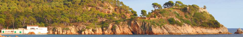
The track climbs into the hills and it becomes clear that the dry ravines and rocky terrain make the over the hill route the most practical. The path up climbs for ages, and below us we can see Cadaques and the sea. Up above are one or two white farmhouses in among the scrubby landscape and above them a radar or observation point but little else. Most of the countryside is quite harsh, made up of low knee-high or thigh-high shrubs, gorse and rosemary packed in amongst jagged rock formations. Despite being isolated, we do get overtaken by a couple of mountain bikers and see a few other walkers also following the path.
 With the climb and the dry heat, even this early in the walk we're talking on water. There are boats out on the sea in the distance and we can just see a lighthouse. One feature of Cap de Creus that always intrigues me is the number of terrace walls and the amount of terracing, much of it overgrown and disused now. Since creating terraces and dry stone walls would have been very hard work, I wonder why the terraces were abandoned. The modern climate seems too dry to make it worthwhile for farming. Perhaps they were grapes that were abandoned in the phyllexora outbreaks at the end of the 19th Century, or olive groves out competed as transport improved, or perhaps the past was just wetter and more fertile than now?
Towards the top, we pass another farmhouse, well-renovated with grand views situated by a small stream that surprisingly enough had a small amount of water, enough for Zina to quench her thirst, and the walk levels out across the top.
 After a while the track turns around the hill and we lose sight of Cadaques and catch our first glimpse of the bays and hills on the other side of the cape. There are roads and the odd car in the distance, but our path leaves the dusty track and takes a smaller path, hugging a hill-line down to a distant bay beneath us. The path is well walked and looks like it has been laid with supporting stones on the side.
The bay ahead of us is Cala Joncols and we can see yachts in the water under the cliffs. A steady stroll down the hill and we arrive at a house and then down to a small nest of houses on the bay itself. There are cars too and a car park that is reasonably full, particularly given the only access is by a gravel-track road.
The beach is broad and has people and another small river with water. At the back is a hotel, and a tourist boat is pulled up to a platform just off the beach. The sign post points to steps and track up from the far side of the beach, and we head up again into the shrub. For some reason we miss the path and get a little lost in amongst the gorse and just try to head up to see if we can see a way out. At the top we can see a couple of other hikers picnicking and that helps us get back to the path.
 At this point we're cross the peninsula of Cap Norfeu, and from the top we can see the bay behind us and the coming bays on the way to Roses. For anyone with a boat, this seems to be the place to come and there are plenty of yachts and boats moored in each bay.
On the other side we walk to another signpost, and see a few more cars. The signpost says the GR92 goes along the peninsular a little way before swinging back around, but we find that this way around we can't find the path down that was marked. It looks as the only paths are heading up to the small tower on the top of Norfeu. It's only when we look back from the other side of the bay we can see how the path runs along the side of the headland and we just had to trust that the path would turn back.
Instead we walk down the fence to join the GR92 a little further along and then along the low cliff tops above the sea to the small bay at Pelosa where an open air restaurant is heaving with people and scattered families are playing on the beach.
 From here we follow the path around the bay-tops before having to join the road to be able to reach Cala Montjoi. We're passed by a few cars on the road and they throw up clouds of grey dust, so it's a relief to find steps down to the Cala.
Cala Montjoi itself is famous, though you might not have heard of it. It's the location of El Bulli, the world famous 3-star restaurant run by Ferran Adria, proclaimed the best in the world until it closed in 2011. Now they are transforming the restaurant into El Bulli Foundation reworking all the buildings. However, the bay and beach themselves are very pleasant - with a broad sandy beach, open and natural with a campsite in the back.
From Montjoi, the path climbs up over the top of the next set of cliffs - higher this time with views back to Norfeu. By now we're getting a little tired, but there is a constant up and down as we go up and down for the next couple of bays to Cala Murtra, the last of the swimming type beaches before Punta Falconera, and a naturist beach from the last time we walked this way.
 From here we climb again to the top and the path runs on top of the cliffs (not too close to the edge). Punta Falconera has old gun emplacements built into the ground that look out towards the Bay of Roses and across to the Isles Medes and Montgri on the far side of the bay. On a clear day you can see for miles down the Costa Brava, or looking back to the hills and mountains in the distance behind Roses.
We're now on a route we know and we head back towards Roses and reach the first built up areas for the bay of Platja Almadrava, full of sunbathers and holiday makers enjoying the sand or the bars and restaurants. We carry on following the man-made path around the bays to be met at Platja Canyelles, before a further walk in and on past Roses town to find the car.
See also: Port de la Selva - Roses - Canyelles beaches to Cap Falconera - Roses and Roses Ciutadella - Cadaques and Port Lligat - Llança - Sant Pere de Rodes - Espolla to Rabos - La Jonquera to Fort de Bellegarde (France)

