Ruta del Carrilet - Girona cyclepath to the coast
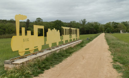 The Costa Brava and Girona area is a fabulous area for all types of cycling. Professional cycling teams use Girona as a training base and can be seen riding into the mountains up to Vallter 2000, or doing climbs up to Els Angels or Rocacorba, or tracking around the coastal route between Sant Feliu de Guixols and Tossa de Mar. Others take mountain bikes up into the Gavarres, or out into the hills of the pre-Pyrenees.
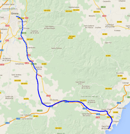
For less arduous cycling, a number of old railway routes have been converted into easy flat cycles paths or green-ways (Vies Verdes), that can also be walked. Close to the coast between Palafrugell and Palamos is the relatively short Ruta del Tren Petit, but for something longer the Ruta del Carrilet (http://www.viesverdes.cat/CA/54/RUTA-DEL-CARRILET-II.html) runs from Olot down through Girona and then to Sant Feliu de Guixols via Cassa de la Selva and Llagostera - a total length of 93km.
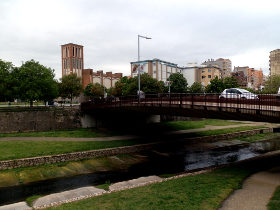 To provide a taste of the route, I walked the stretch from Girona to Cassa de la Selva while the family was shopping in Girona, getting picked up as they drove back home. Girona to Sant Feliu (or diverting north to Platja d'Aro) is about 39km.
The first thing to note is that this is a route that is really best done by bike than on foot. The path is gravel but fairly broad and solid under foot and it encourages you to speed through the countryside on long straight routes through the fields, with not too many diversions for walkers who might like to explore a little more into the centre of the towns and villages.
Our starting point was in Girona at the Pont de la Font del Rei across the River Onyar in Girona. The Onyar is the smaller of Girona's two rivers, but the one that runs along the old city in the centre before meeting the River Ter just beyond the Cathedral on the way out to the sea at L'Estartit.
 We could track the river in a couple of directions - there's a path along the channel, or two road routes, one either side of the river. The main bike route stays on the south side of the river, but wanting to explore a little we took the left-bank, north side under the hill with the great radio mast and out along the plane-tree lined road.
At the crematorium (Tanatori) I realised we were making a bit too much of a diversion, so we crossed down to the river across a narrow zig-zag foot bridge and out to the Parc Scientific of the University of Girona. From here we took the Ruta de Carrilet proper into the fields tracking the Onyar against the flow. It's spring with a relatively wet April so the fields are full of wheat and poppies and the yellows of rapeseed and marigolds. The rain seems to have put off the cyclists a little and though we see a few on the route, it's not as busy as it has been in the past.
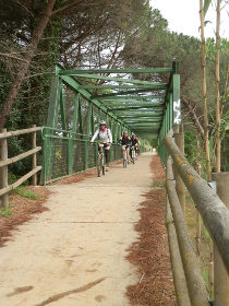
 The path reaches the NII and double backs to pass under the road - there's a split point here and it would be possible to continue straight on to walk to the southern parts of Girona. We take the marked path and then cross the Onyar using a green-box bridge across the water just as a group of cyclists meet us. The rules for the path say dogs must be on a lead, and since the bike go relatively fast, I keep Zina on the lead whenever there are bikes about.
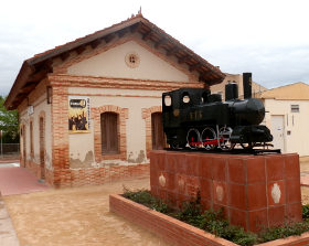
The path continues it's very straight, but slightly uphill passage to Quart, the first small town outside Girona. The runs along a back road through the village, past the quaint old station marked with a model train and then past the small Museum of Terrissa (pottery).
On the far side of Quart the path is back to gravel and runs alongside the main Girona-Sant Feliu road so there's the steady hum of traffic. A yellow-painted metal train sign marks the route for the cars but otherwise it's a steady walk to Llambilles and the next disused station. In the park nearby a collection of bike statues mark how popular the route has become for local cyclists.
 We track even closer to the road for a while with more box-bridges, but with almost no-one on the path now. The route deviates a little from the road behind a Repsol station and over the hill we can see the tower marked Inresa in stencil letters of Cassa de la Selva. It's a steady walk past the odd farm house through the fields.
As we reach the outskirts of Cassa de la Selva, the Carrilet path tracks through the industrial estate (poligon industriel) past large grey warehouses, quiet on a Saturday afternoon, but not particularly enticing for walking. On a bike you'd zoom through, but on foot it takes a while before the Carrilet turns up towards the town of Cassa de la Selva.
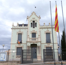
We go past Cassa's old station and the very ornate Can Nadal before heading out into the countryside again. The road leaving Cassa isn't so well marked so at one point we thought we had lost the path, but after climbing past farms and then over the main road we see we're on the right path as the signposts point across the countryside towards Llagostera.
We're about done though. Shopping has finished in Girona so we leave the Carrilet and take a track to the last Cassa roundabout to wait for our lift home.
Girona walks: Girona valley of Sant Daniel - Gavarres Montnegre and Montigalar - Girona and Castell de St Miquel - Roman fort at St Julia de Ramis (Girona) - Girona - Festa Major of Sant Narcis - Girona Temps de Flors - Llagostera to Sant Llorenç - Cassa de la Selva

 Walks and other things